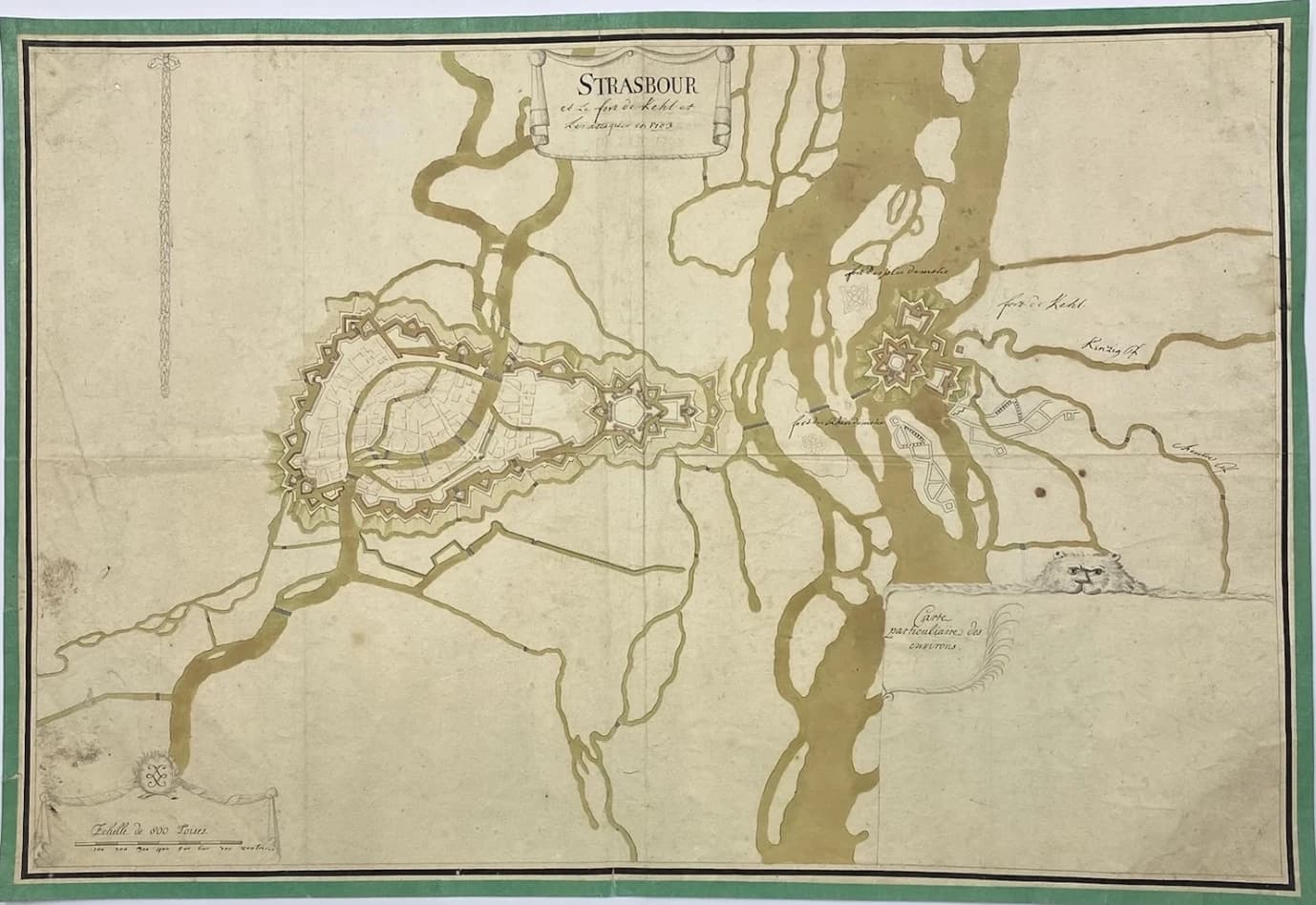

Manuscript plan of Strasbourg and Kehl
Strasbourg and the fort of Kehl and The attacks of 1703. Anonymous Manuscript, ca 1730. Contemporary colouring. Plan size: 45.5 x 68 cm Leaf size: 47.2 x 69.6 cm A finely executed, watercoloured plan. Unfinished: the cartouche "Carte particulière des environs" is not drawn, although its place is laid out. The title of Strasbourg, without the "G", bears witness to a time when the spelling of town names could still commonly vary. Beneath the pen title, the working title can be faintly read in pencil. Some roads are drawn but not yet watercoloured. Note reinforcement restorations to three longitudinal folds, on the verso. And a few very slight losses, of no consequence, at the lower left edge, lower middle and upper left edge. Soiling at the lower left corner. The whole drawing is framed by a green border. In 1703, Marshal Claude Louis Hector de Villars took the fort of Kehl, the key to the crossing of the Rhine. It was a French victory that secured Alsace against the Holy Roman Empire.
Manuscript, ca 1730. Contemporary colouring.




![[Manuscrit] Jaufré und Mélisande. Eine Troubadourgeschichte von Paul Ernst.](/_next/image?url=https%3A%2F%2Fssjqsarnhyfejpmgyftq.supabase.co%2Fstorage%2Fv1%2Fobject%2Fpublic%2Fmedias%2F88c8af43-c6d2-4d18-bb4b-f42f881a643b%2F1779392582975-60sonh-972.jpg.webp&w=3840&q=75)
![[STRASBOURG] Projet d'Allignement des Environs de l'Eglise de St. Pierre-le-Vieux.](/_next/image?url=https%3A%2F%2Fssjqsarnhyfejpmgyftq.supabase.co%2Fstorage%2Fv1%2Fobject%2Fpublic%2Fmedias%2Fff6bfd47-2bb1-44d1-b3d4-9736bdbbf482%2F925.webp&w=3840&q=75)